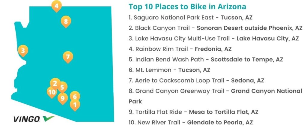
Top 10 Bike Trails in Arizona
- 1. Saguaro National Park East – Tucson, AZ
- 2. Black Canyon Trail – Sonoran Desert outside Phoenix, AZ
- 3. Lake Havasu City Multi-Use Trail – Lake Havasu City, AZ
- 4. Rainbow Rim Trail – Fredonia, AZ
- 5. Indian Bend Wash Path – Scottsdale to Tempe, AZ
- 6. Mt. Lemmon – Tucson, AZ
- 7. Aerie to Cockscomb Loop Trail – Sedona, AZ
- 8. Grand Canyon Greenway Trail – Grand Canyon National Park
- 9. Tortilla Flat Ride – Mesa to Tortilla Flat, AZ
- 10. New River Trail – Glendale to Peoria, AZ
- Interested in another state?
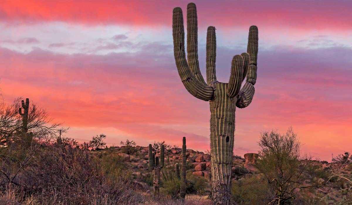
Arizona is one of the top biking destinations in the country, with tourists flocking to the state year-round and pros like Lance Armstrong making their way to areas like Tucson to train. Whether you’re a pro cyclist or just looking for a new place to explore on your bike, we’ve compiled ten of the best and most scenic routes in the state.
1. Saguaro National Park East – Tucson, AZ
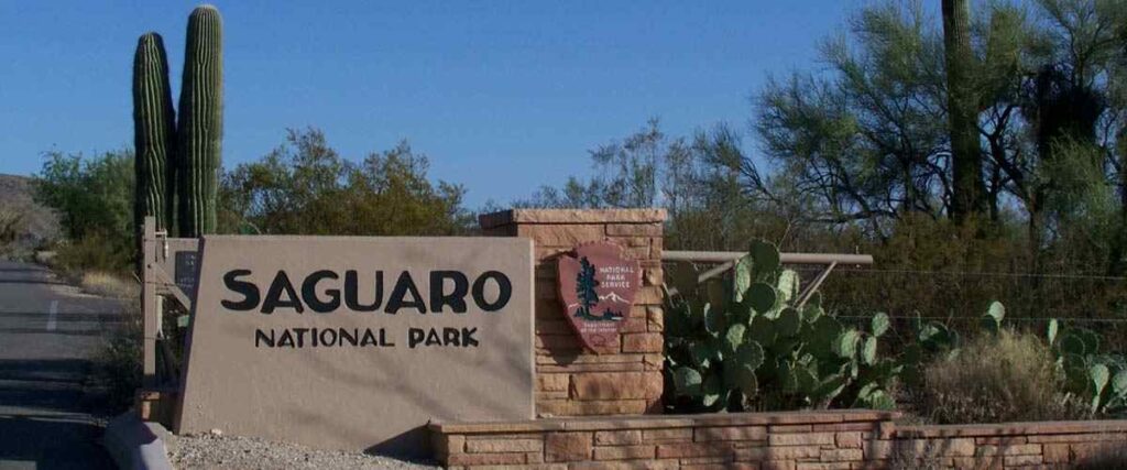
Tucson is one of the most bike-friendly cities in the U.S. One of the most popular bike rides in this area is the 8-mile Saguaro National Park East Loop, also called Cactus Forest Loop Road or “The Loop.”
The Saguaro National Park East Loop is fully paved and meanders through the lower elevations of the Rincon Mountain District. Although it’s a rather hilly ride, it’s great for families, beginner cyclists, or even advanced bikers who want a leisurely ride. As you ride the trail through the cactus forest, you’ll enjoy the beautiful desert scenery and local wildlife. Just make sure to keep your eyes on the road because this trail features several tight turns and steep hills.
To get to the Rincon Mountain District, commonly called the Saguaro National Park East, head to 3693 S. Old Spanish Trail, Tucson, Arizona 85730.
Tips: This trail is also open to cars and pedestrians, so take it slow on those curves and hills.
2. Black Canyon Trail – Sonoran Desert outside Phoenix, AZ
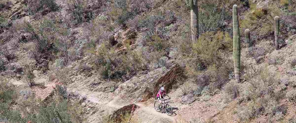
One of Arizona’s famous IMBA Epic rides, the Black Canyon Trail is a rigorous 80-mile ride through the Sonoran Desert outside Phoenix. Not at all for the faint of heart, this bike route is far out in the wilderness, with very little road access or cell service.
This route winds through the desert landscape and red rock canyons, featuring massive 50-foot-tall saguaro cacti that tower high above you as you make your way through the rugged backcountry. Although it’s a very scenic and rewarding ride, you’ll have to push through rough, unstable dirt and rocks while navigating varying grade and elevation changes. We should also note that this trail has national historic significance: It follows a route used since the times of prehistoric Native American travelers and traders.
If you’re up for the challenge, bite off a section of the Black Canyon Trail for an exciting, one-of-a-kind cycling adventure! You can access it via multiple trailheads throughout the route.
Tips: Due to the harsh desert climate of this area, it’s safest to bike the Black Canyon Trail from November through April.
3. Lake Havasu City Multi-Use Trail – Lake Havasu City, AZ
The Lake Havasu City Multi-Use Trail parallels Arizona Highway 95 through Lake Havasu City from north to south. It offers a nice 8.5-mile ride with a scenic view of the city and its lake. The route is mostly flat and paved, with a few climbs and descents, including one steep 4-mile climb from S. McCulloch Boulevard, south toward Mulberry Avenue.
However, the real highlight of this biking route is the original London Bridge, which you’ll find at about the halfway point of the trail. It was originally built in the 1830s and spanned the Thames River in London, England before it was dismantled, shipped to America, and rebuilt across Lake Havasu.
The Lake Havasu City Multi-Use Trail begins at S. McCulloch Boulevard and ends on the north side of town at N. Palo Verde Boulevard. You can park on the side streets all along the trail.
Tips: After you ride, head to the nearby Lake Havasu State Park, where you can enjoy beautiful beaches and nature trails.
4. Rainbow Rim Trail – Fredonia, AZ

Just outside the Grand Canyon National Park in Kaibab National Forest, you’ll find the stunning Rainbow Rim Trail: one of the most extraordinary and well-known mountain bike rides in America’s Southwest. Located along the rim of the Grand Canyon, this trail passes through an ancient Ponderosa Pine forest and drops into several steep canyons filled with beautiful aspens and flower-filled meadows.
The Rainbow Rim Trail is 18 miles one way and is at an average altitude of 7,700 feet. It’s rated as a moderately difficult ride. The trail links five different observation points, offering sweeping and spectacular views of iconic Grand Canyon features, including Great Thumb Mesas, Steamboat Mountain, and more. Overall, you can expect breathtaking views, fast descents, technical canyon riding, and relatively smooth climbs.
For directions to the Rainbow Rim Trail, visit the USDA Forest Service website.
Tips: This is another backcountry trail, and it’s very remote. Bring enough water and food for your ride, and don’t forget to pack a bike repair kit! You can also camp around the observation points and break your ride up into a several-day trip.
5. Indian Bend Wash Path – Scottsdale to Tempe, AZ
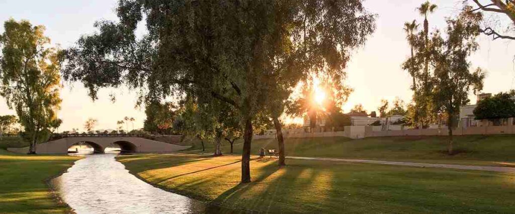
The Indian Bend Wash Path (also called the Indian Bend Wash Greenway) spans 11 miles through the heart of Scottsdale. This beautiful winding pathway knits together several parks, lakes, and golf courses and features more than two dozen tunnels and overpasses, limiting cyclists’ encounters with road traffic.
The Indian Bend Wash Path follows the banks of Indian Bend Wash between Scottsdale and Tempe, offering plenty of amenities and nature areas to enjoy as you ride. One of the highlights of the trail is Eldorado Park, a 60-acre park with a swimming pool, a lake for fishing, a skate park, playgrounds, and picnic areas. It’s about halfway along the route, making it a great stopping point for lunch.
For easy access to the Indian Bend Wash Path, you can park at Eldorado Park (2311 N. Miller Rd., Scottsdale) or Chaparral Park (5401 N. Hayden Rd., Scottsdale).
Tips: This trail also connects to several other cycling routes in this area. You can continue your ride on the Rio Salado Pathway at the southern end of the path. Or, at the north end, you can connect to the Arizona Canal Path or the Central Arizona Project to Arizona Canal Trail.
6. Mt. Lemmon – Tucson, AZ
Mt. Lemmon is one of the most scenic bike rides in the state and a favorite among local cyclists. Lance Armstrong and other pro cyclists have even used it as a training ground! This grueling climb to Mt. Lemmon can be anywhere from 30 to 60 miles, depending on where you start and end, and has an elevation gain of 7,159 feet.
This ride is along a paved road with a wide shoulder for most of the route. Although you’ll start off in desert scenery, surrounded by mesquite trees and saguaro cacti, you’ll end up in a forest of pine trees, breathing in the crisp, cool mountain air. Generally, bikers only recommend riding up the Catalina Highway to Mt. Lemmon if you’re an experienced cyclists.
To bike this route, you can start from anywhere in Tucson. Most people park their cars in the Safeway shopping center at the intersection of Tanque Verde Road and Catalina Highway and start the ride from there.
Tips: Dress warmly. Although you might be hot at the start of your ride, you’ll need the extra layers once you reach the top! Also, be careful descending the mountain at high speeds.
7. Aerie to Cockscomb Loop Trail – Sedona, AZ
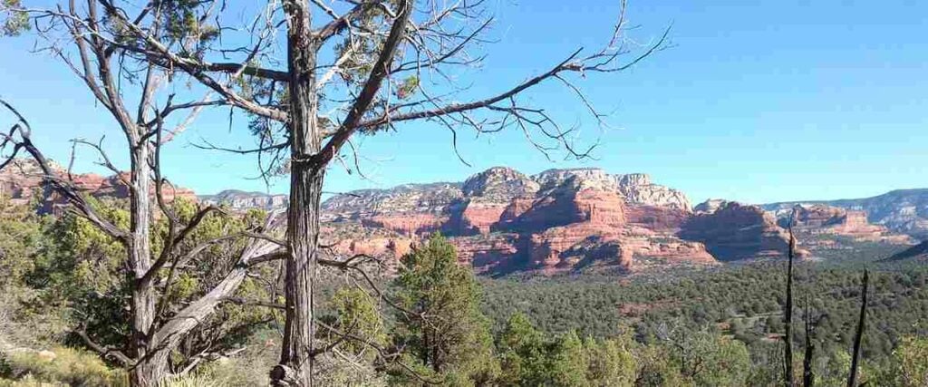
Sedona is one of the top areas for mountain biking in the state. Although there are tons of excellent trails to check out, one of the best in the area for intermediate-level riders is the Aerie to Cockscomb Loop Trail.
This 6.1-mile loop combines the Aerie Trail with the Cockscomb Trail for one incredible and scenic ride. If you start at the Boynton Canyon Trailhead, you’ll start on a fun and curvy track before reaching the main loop. From there, the trail takes you on an adventurous ride up and around Doe Mountain. Be ready for some epic descents on the way back down!
For directions to the Boynton Canyon Trailhead, visit the USDA Forest Service website.
Tips: This area is known for its outstanding scenery, featuring natural desert gardens, towering buttes, and red cliffs. Bring a camera or your phone for pictures! It has also developed a reputation for being the site of a spiritual energy vortex. Some people believe the energy sources at these vortexes inspire and facilitate healing, balance, prayer, and intuitiveness.
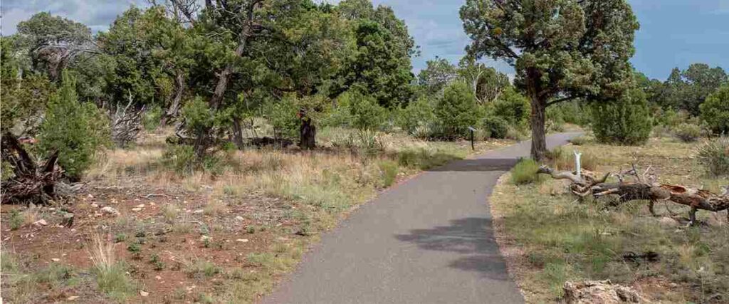
8. Grand Canyon Greenway Trail – Grand Canyon National Park
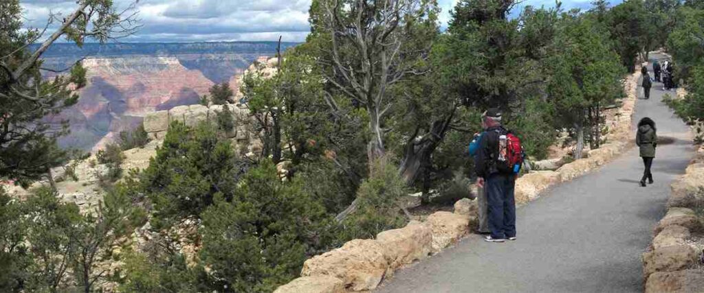
If you want to bike the Grand Canyon but aren’t too keen on offroading adventures, the Grand Canyon Greenway Trail is the perfect way to explore this national park by bike. The trail features 13 miles of paved pathways for bikers, runners, and walkers and connects several scenic viewpoints and attractions in the park.
While you ride this greenway trail system, you’ll be completely immersed in the natural beauty of the Grand Canyon National Park. Meander through the ponderosa, pinyon, and juniper forest, peer down into the steep, red canyon below, and relish in all the interactions with local wildlife, such as bighorn sheep, and gray foxes, elk, and so much more. Overall, this ride is perfect for cyclists of all skill levels, although there are a few steep climbs to watch for at 1.4, 2.5, and 4.3 miles (if you’re headed north).
Parking for this trail is available at the Grand Canyon Visitor Center at Mather Point on the South Rim.
Tips: You’ll have to pay an entrance fee to get into the park, even if you ride in on your bike. However, you can bypass this by going on a “Fee-Free Day,” which the park offers several times a year.
9. Tortilla Flat Ride – Mesa to Tortilla Flat, AZ
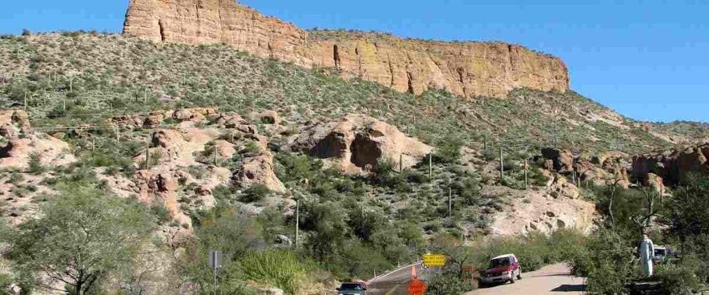
The Tortilla Flat Ride along Highway 88/Apache Trail is a scenic and twisty ride through the breathtaking Superstition Mountain Range. Starting just east of Mesa and leading to the small town of Tortilla Flat, the entire route is about 60 miles, features an elevation gain of 3,077 feet, and is well-loved by visiting and local road cyclists.
This rolling section of highway is well-maintained, but there isn’t a shoulder to ride on, so you’ll need to be cautious and aware of road traffic. This road gradually ascends into the remote landscape before descending into the Salt River Canyon. Often described as a “roller coaster of a ride,” this route takes you along the beautiful Canyon Lake and eventually leads you to the old western saloon at Tortilla Flat. If you cycle on this road in March or April, you’re also likely to catch views of gorgeous wildflower meadows. With plenty of pit stops along the way, it’s convenient to break for a quick meal, drink, or rest if you need it.
Tips: During the summer months, this road gets packed with vehicles heading to the lake, so it’s best to ride in the spring, fall, and winter to avoid all the traffic.
10. New River Trail – Glendale to Peoria, AZ
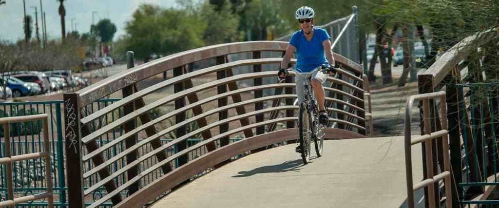
The New River Trail is a 13-mile paved pathway that runs parallel to the New River through Peoria and Glendale, two highly-populated Phoenix suburbs. It connects several neighborhoods, businesses, and parks, diverting cyclists below major thoroughfares to prevent interactions with dangerous traffic conditions.
The trail’s southern end starts in Glendale, where cyclists have easy access to the Westgate Entertainment District, featuring specialty shops, restaurants, and entertainment. It wanders through business and residential areas northwest of Highway 101 and features plenty of native plants and natural areas, making it ideal for wildlife viewing. Stop at the 52-acre Rio Vista Community Park for a quick rest, where you’ll find an urban lake, picnic areas, splash park, and more. The park also has water fountains and bathrooms.
You can start this ride at any point along the route, but the south end of the trail is at W. Bethany Home Road and N. 107th Avenue in Glendale. The north end is along the New River, a half-mile north of W. Deer Valley Road in Peoria.
Tips: If you want to extend your ride, consider checking out the nearby Skunk Creek Trail or Grand Canal Trail.
Interested in another state?
Discover the best US places to ride a bike:
- Alabama
- Arizona
- Arkansas
- California
- Colorado
- Connecticut
- Florida
- Georgia
- Hawaii
- Idaho
- Illinois
- Iowa
- Indiana
- Kansas
- Kentucky
- Louisiana
- Maryland
- Massachusetts
- Michigan
- Minnesota
- Missouri
- Mississippi
- Nebraska
- Nevada
- New Jersey
- New Mexico
- New York
- North Carolina
- Ohio
- Oklahoma
- Oregon
- Pennsylvania
- Rhode Island
- South Carolina
- Tennessee
- Texas
- Utah
- Virginia
- Washington
- West Virginia
- Wisconsin
Tired of hypercompetitive fitness apps?
Enjoy Vingo’s judgment-free community!![]() Explore new worlds on many different terrains
Explore new worlds on many different terrains![]() Personalize your avatar with cool clothes and gears
Personalize your avatar with cool clothes and gears![]() Experience Vingo anywhere on any exercise bike or treadmill
Experience Vingo anywhere on any exercise bike or treadmill
References:
- https://www.nps.gov/sagu/planyourvisit/where2bike.htm
- https://www.blm.gov/programs/recreation/mountainbike/blackcanyon
- https://www.mtbproject.com/trail/7000113/black-canyon-trail-bct-imba-epic
- https://www.traillink.com/trail/lake-havasu-city-multi-use-trail/
- https://www.golakehavasu.com/cycling
- https://www.fs.usda.gov/Internet/FSE_DOCUMENTS/fseprd738423.pdf
- https://www.traillink.com/trail/indian-bend-wash-path/
- https://www.scottsdaleaz.gov/parks/greenbelt
- https://www.experiencescottsdale.com/stories/post/the-indian-bend-wash-greenbelt/
- https://www.tucsonbikerentals.org/best-tucson-roadbike-rides/arizonas-greatest-road-biking-ride/
- https://bikeaz.org/bikemountlemmon/
- https://www.alltrails.com/trail/us/arizona/mescal-aerie-cockscomb-and-dawa-loop
- https://www.alltrails.com/trail/us/arizona/grand-canyon-greenway-trail
- https://www.traillink.com/trail/grand-canyon-greenway/
- https://www.nps.gov/grca/planyourvisit/bicycling.htm
- https://www.arizonabikerides.com/rides/288/tortilla-flats-road-bike-ride-mesa-arizona/
- https://www.traillink.com/trail/new-river-trail/
Photo Sources:
Ray Redstone, CC BY-SA 4.0, via Wikimedia Commons
Eegorr, CC BY 3.0, via Wikimedia Commons
Bureau of Land Management, Public domain, via Wikimedia Commons
Deborah Lee Soltesz, CC0, via Wikimedia Commons
Nicholas Hartmann, CC BY-SA 4.0, via Wikimedia Commons
Ivgotit at English Wikipedia, CC BY-SA 3.0, via Wikimedia Commons
davidpinter, CC BY 3.0, via Wikimedia Commons
Grand Canyon National Park, CC BY 2.0, via Wikimedia Commons
Bernard Gagnon, CC BY-SA 3.0, via Wikimedia Commons
Places for Bikes, CC0, via Wikimedia Commons


.jpg)
.jpg)
_0132_(6225140496).jpg)
.jpg)