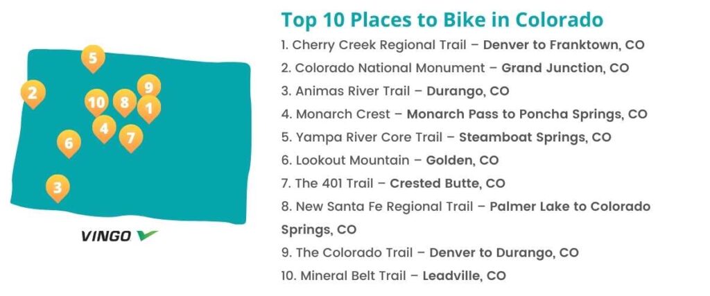
Top 10 Bike Trails in Colorado
- 1. Cherry Creek Regional Trail – Denver to Franktown, CO
- 2. Colorado National Monument – Grand Junction, CO
- 3. Animas River Trail – Durango, CO
- 4. Monarch Crest – Monarch Pass to Poncha Springs, CO
- 5. Yampa River Core Trail – Steamboat Springs, CO
- 6. Lookout Mountain – Golden, CO
- 7. The 401 Trail – Crested Butte, CO
- 8. New Santa Fe Regional Trail – Palmer Lake to Colorado Springs, CO
- 9. The Colorado Trail – Denver to Durango, CO
- 10. Mineral Belt Trail – Leadville, CO
- Interested in another state?
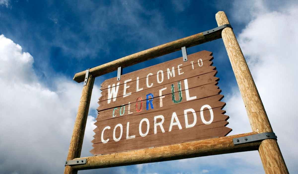
Whether you prefer rigorous mountain biking or you’re searching for a fun, family-friendly bike ride, the beautiful state of Colorado has it all. These top 10 cycling routes are sure to provide a fantastic ride, incredible views, and an exciting way to explore the tremendous and historic landscape of colorful Colorado.
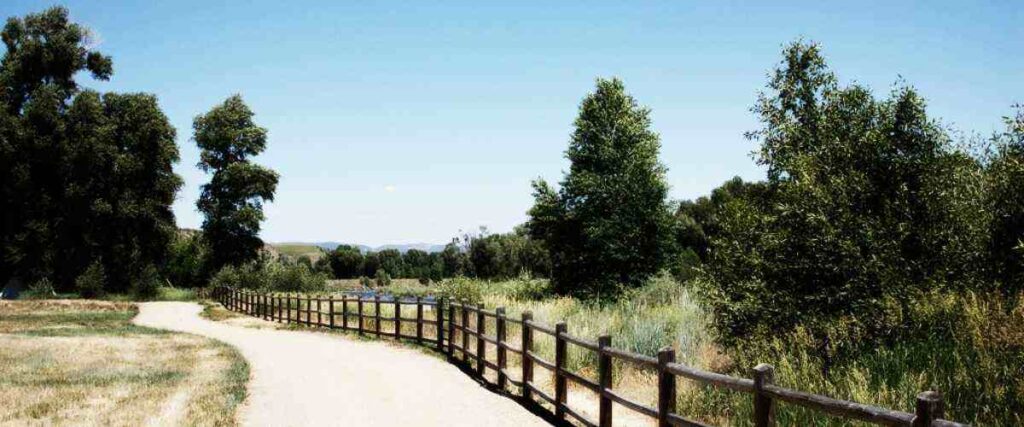
1. Cherry Creek Regional Trail – Denver to Franktown, CO

The Cherry Creek Regional Trail is a scenic 40-mile trail that starts in downtown Denver and meanders out into charming nearby suburban and rural communities. Most of the route is concrete, but the southernmost sections are sometimes gravel or road.
Start your ride at the Platte River Trail at Confluence Park in Denver and follow Cherry Creek through the city. In this area, you’ll be very close to the Denver Center for the Performing Arts and Larimer Square, where Denver first began back in the 1850s! As you cycle further out into the suburbs, you’ll pass through Cherry Creek State Park, a stunning 4,000-acre wildlife oasis, under State Road 88 (without crossing busy traffic) and through the Parker Jordan Centennial Open Space. The trail ends in Franktown, just a few miles from Castlewood Canyon State Park.
Trail parking is available at Confluence Park in Denver and several other areas along the route.
Tips: Although the southern portion of this trail is very rural, there are many breweries, restaurants, coffee shops, and more to explore in the Denver area where this route begins.
2. Colorado National Monument – Grand Junction, CO
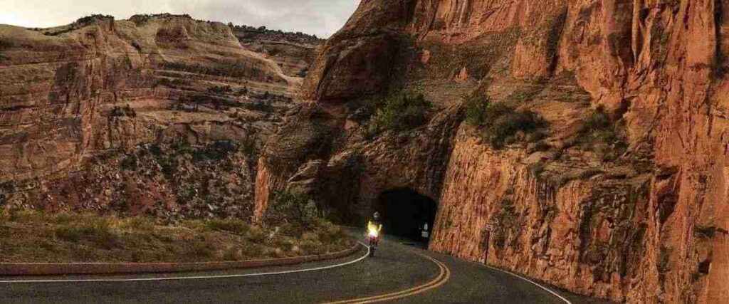
Colorado National Monument features a stunning desert high canyon landscape that serves as a one-of-a-kind backdrop for cycling. The most popular biking route through the area is the main road, Rim Rock Drive, which passes through the park.
Rim Rock Drive stretches on for 23 miles, and the road itself has a 25 mph speed limit for cars. Several overlooks along the route allow you to stop and soak up the views, and the spectacular ancient red rock canyons dotted with green junipers are gorgeous from any angle as you traverse your way through the park.
There is one entrance at each end of Rim Rock Drive, with the west entrance being just four miles from the Visitor’s Center.
Tips: Be cautious and aware of your surroundings while biking at Colorado National Monument. Cyclists and motorists share the road on Rim Rock Drive, and some sections have tight corners and sheer drop-offs.
3. Animas River Trail – Durango, CO
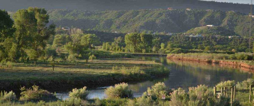
The Animas River Trail follows the Animas River for a little over 9 miles. It also follows the active Durango and Silverton Narrow Gauge Railroad corridor in some areas.
You can start your ride at Animas City Park in Durango and follow the trail as it heads south. The route cuts across several bridges and through multiple city parks for a scenic and easy ride. It also cuts through downtown Durango along a river walk and offers easy access to the community recreation center, public library, local neighborhoods, and schools.
There are parking areas all along the trail, depending on where you want to start and end your ride.
Tips: This trail is a fun way to explore Durango and is excellent for families, as it doesn’t require that you cross any trafficked streets.
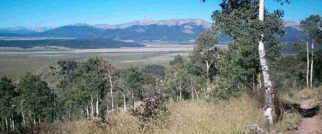
4. Monarch Crest – Monarch Pass to Poncha Springs, CO
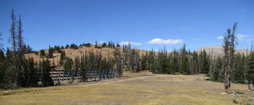
Monarch Crest is an IMBA Epic bike ride, which means it’s officially designated as an incredible bike ride, according to the International Mountain Bicycling Association. The route stretches 35 miles from Monarch Pass to Poncha Springs. If you ride the trail this way, you’ll gain 2,281 feet and lose 6,100 feet.
The majority of this route is a singletrack trail and reaches an elevation of 11,900 feet! The official Monarch Crest combines three different trails: the Monarch Crest Trail (14 miles), the Silver Creek Trail (4.5 miles), and the Rainbow Trail (10 miles). An additional five miles of road riding will get you to Poncha Springs, where the route ends.
You’ll want to arrange for a shuttle vehicle to drop you off on the east side of Monarch Pass.
Tips: Most of the trail is a ride through the wilderness, so you should plan to bring lots of water, food, and a map.
5. Yampa River Core Trail – Steamboat Springs, CO
The Yampa River Core Trail is a 7-mile trail that follows the Yampa River and parallels U.S. 40 through the city of Steamboat Springs in northern Colorado’s Yampa Valley. The paved trail provides easy access to year-round area attractions, several parks, and Steamboat Springs, a popular skiing destination in Colorado.
As you bike this trail, you can easily take in the sights and sounds of the beautiful area’s surroundings. Although the trail is short, it’s relatively flat and easy to bike, with plenty of fun things to do and see along the way! Whether you take a quick detour downtown, stop off at the local botanical garden, or check out the area’s naturally-occurring hot springs, there’s no shortage of fun things to experience along this route.
To access the trail, you can park at either end of it.
Tips: Since this trail is shorter, it’s a great idea to take advantage of one of the many activities along the way. However, there are tons of great options, so do your research before you head out!
6. Lookout Mountain – Golden, CO
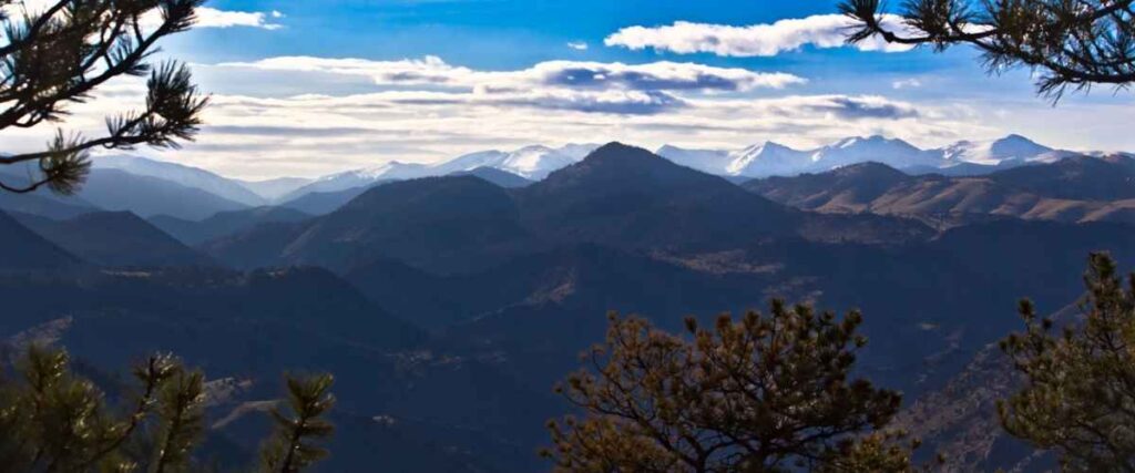
Lookout Mountain towers 7,300 feet above the city of Golden, CO, and it’s famous for road cycling. If you choose to make your way up to the top, just be prepared for one steep climb, a fantastic workout, and some gorgeous views!
Starting from downtown Golden, the twisting road up Lookout Mountain is only 5 miles, but it’s a rigorous climb with 5 to 6% grades. Once you get to the top and have had time to soak in the views, you can extend your bike ride further by making your way to CO 40 and cycling through the quiet mountain neighborhoods. Alternatively, you can head down Grapevine Road south of I-70, which will take you to Idledale, just south of Golden.
You can start and end your ride to Lookout Mountain in downtown Golden, where you’ll also have access to several breweries and restaurants for a delicious victory meal.
Tips: Once you bike up Lookout Mountain, stop at Buffalo Bill’s Museum and grave for a historical tour. You can also grab a cold drink and a snack at the gift shop.
7. The 401 Trail – Crested Butte, CO
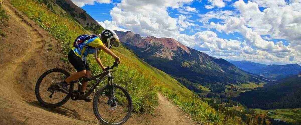
Crested Butte is a former coal-mining town about 200 miles from Denver, and it’s also one of the birthplaces of modern mountain biking, with more than 700 miles of singletrack. The mountainous terrain is perfect for cycling, and although the town is small, there are at least 7 local bike shops and bikers everywhere!
One of the best things about cycling in Crested Butte is that there are trails for bikers of all experience and skill levels. However, one of the more popular rides in Crested Butte is the 401 Trail, a 14-mile alpine singletrack loop ride. Featuring breathtaking views of Colorado’s Elk Range, this challenging route has a maximum grade of 30%, which is sure to challenge you. At its highest, this trail leads you up to 11,300 feet, so be ready for unbeatable mountain views. The final descent will bring you back down to the outskirts of Gothic.
To get to the 401 Trail, you can bike a quick 5 miles up Gothic Road to Schofield Pass. The route begins at the top of Schofield Pass.
Tips: Crested Butte sits at 8,850 feet in elevation. Before you bike here, you’ll need to plan to acclimate to the elevation.
8. New Santa Fe Regional Trail – Palmer Lake to Colorado Springs, CO
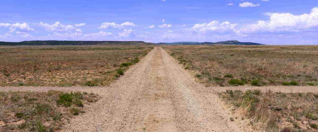
The New Santa Fe Regional Trail parallels the base of the Rocky Mountains for about 17 miles, featuring majestic views of Pikes Peak and more. The trail primarily has a crushed stone and gravel surface and is very popular among cyclists and hikers, so you’re bound to run into other people when you ride here.
All along the New Santa Fe Regional Trail, you’ll find interpretive signs, encounter plenty of local wildlife, and ride past fascinating geological features in the area. The route also takes you through the town of Monument, where you can stop to explore the local shops and restaurants. The New Santa Fe Regional Trail connects with the Pikes Peak Greenway Trail at its southern end for another 15 miles of riding.
This trail has several access points along the way, so you can start and end at any point.
Tips: While you’re biking on this trail, don’t be surprised if you see jets flying overhead! The Air Force Academy is also in the town of Monument, so you’re likely to see cadets training in the skies.
9. The Colorado Trail – Denver to Durango, CO
The Colorado Trail is a massive 500-mile hiking and biking trail that connects Denver to Durango, offering a ride through the challenging yet rewarding alpine terrain. Biking the entire route will take about 15 to 20 days, so plan accordingly or choose to bike a portion of the trail instead.
If you prefer to bike a shorter part of this route, the more popular portions of this trail for bikers include the areas near Durango, Denver, the Kenosha Pass, and outside Buena Vista. Another popular section of the Colorado Trail near Marshall Pass is shared with the Monarch Crest biking route. Regardless, cycling any part of the Colorado Trail will provide epic mountain views, challenging vertical climbs, and a one-of-a-kind mountain adventure on two wheels. You will encounter other cyclists, lots of hikers, and horses along this trail, so be courteous, slow down, and watch carefully for others.
The Colorado Trail is accessible from many different areas. Do your research before you head out to determine which portion of the trail you will ride and how you will access it.
Tips: Although most of The Colorado Trail is open to mountain bikes, it passes through six wilderness areas where bikes are not permitted. Instead, cyclists are required to detour around these areas.
10. Mineral Belt Trail – Leadville, CO
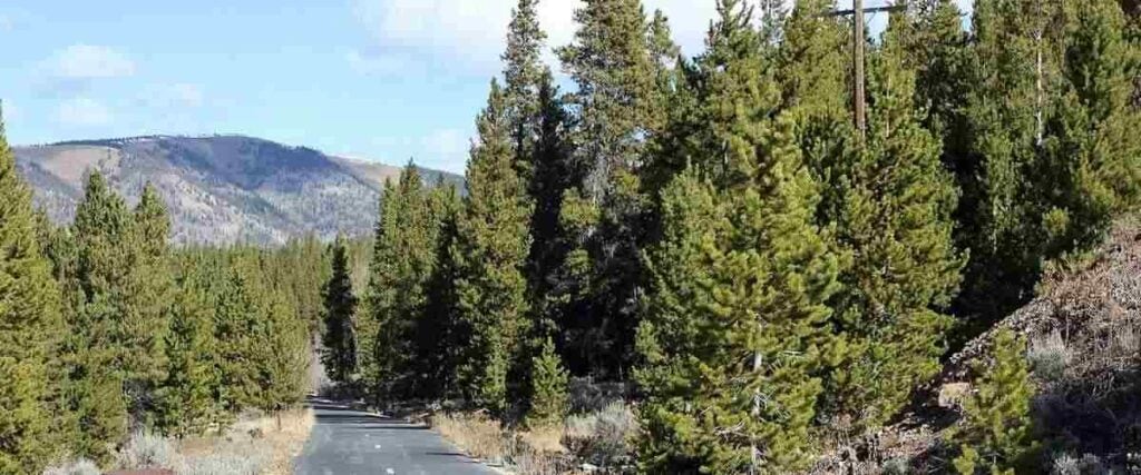
The Mineral Belt Trail is one of Colorado’s highest paved pathways. This 11.6-mile trail is tucked away in the Rocky Mountains of Leadville, Colorado, and is built on three former railroads. The loop surrounds the town of Leadville, giving you a peek into its mining history and the stunning conifer and aspen forests that surround the area.
Not only is it scenic, but the Mineral Belt Trail is also incredibly educational, featuring interpretive signs with fascinating historical tidbits about the area. As you ride, you’ll also enjoy seeing historic relics like an old mining tower, ore carts, and other mining equipment on display along the route. With grades between 3 and 5%, and a high elevation (more than 10,000 feet), the Mineral Belt Trail offers stunning mountain views but can also be challenging if you haven’t had adequate time to adjust to the elevation.
To access this trail, you can park north of downtown Leadville at Ice Palace Park, in West Leadville at Washington Street and W 6th Street, or at the Dutch Henry Trailhead off U.S. Highway 24.
Tips: If you’re struggling with the thin air in the Leadville area, shops within the city sell bottled oxygen that you can bring along with you for your ride!
Interested in another state?
Discover the best US places to ride a bike:
- Alabama
- Arizona
- Arkansas
- California
- Colorado
- Connecticut
- Florida
- Georgia
- Hawaii
- Idaho
- Illinois
- Iowa
- Indiana
- Kansas
- Kentucky
- Louisiana
- Maryland
- Massachusetts
- Michigan
- Minnesota
- Missouri
- Mississippi
- Nebraska
- Nevada
- New Jersey
- New Mexico
- New York
- North Carolina
- Ohio
- Oklahoma
- Oregon
- Pennsylvania
- Rhode Island
- South Carolina
- Tennessee
- Texas
- Utah
- Virginia
- Washington
- West Virginia
- Wisconsin
Tired of hypercompetitive fitness apps?
Enjoy Vingo’s judgment-free community!![]() Explore new worlds on many different terrains
Explore new worlds on many different terrains![]() Personalize your avatar with cool clothes and gears
Personalize your avatar with cool clothes and gears![]() Experience Vingo anywhere on any exercise bike or treadmill
Experience Vingo anywhere on any exercise bike or treadmill
References:
- https://www.traillink.com/trail/cherry-creek-regional-trail/
- https://www.nps.gov/colm/planyourvisit/historic-rim-rock-drive.htm
- https://www.durangotrails.org/trails/animas-river-trail/
- https://www.traillink.com/trail/animas-river-trail/
- https://www.mtbproject.com/trail/3671983/monarch-crest-imba-epic
- https://www.traillink.com/trail/yampa-river-core-trail/
- https://www.visitgolden.com/outdoors/biking/
- https://www.mtbproject.com/trail/338027/401-trail-loop
- https://www.traillink.com/trail/new-santa-fe-regional-trail/
- https://communityservices.elpasoco.com/parks-and-recreation/new-santa-fe-regional-trail/
- https://coloradotrail.org/traveling-the-ct/mountain-biking/
- https://www.mineralbelttrail.com
Photo Sources:
Lovemedead, CC BY-SA 4.0, via Wikimedia Commons
Ahodges7, CC BY-SA 3.0, via Wikimedia Commons
John Sowell, CC BY-SA 4.0, via Wikimedia Commons
J Iannone from Orlando, CC BY 2.0, via Wikimedia Commons
Ligoweth, CC BY-SA 3.0, via Wikimedia Commons
Zach Dischner, CC BY 2.0, via Wikimedia Commons
Hopkins.m.s, Public domain, via Wikimedia Commons
Jeffrey Beall, CC BY-SA 3.0, via Wikimedia Commons
_(2669217727).jpg)
.jpg)