


Top 10 Bike Trails in Massachusetts
- 1. Bruce Freeman Rail Trail – Lowell, MA
- 2. Harold Parker State Forest – Andover, MA
- 3. Blackstone River Greenway – Worcester to Millbury, MA
- 4. Upper Charles Trail – Milford to Hopkinton, MA
- 5. Ashuwillticook Rail Trail – Lanesborough to Adams, MA
- 6. Cape Cod Rail Trail – Yarmouth to Wellfleet, MA
- 7. Lynn Woods Reservation – Lynn, MA
- 8. Border to Boston Trail – Salisbury to Boston, MA
- 9. Columbia Greenway Rail Trail – Westfield, MA
- 10. Vietnam Trails – Milford, MA
- Interested in another state?

Biking is one of the most exciting ways to explore the natural landscape, history, and attractions across the state of Massachusetts. We’ve compiled 10 of the best places to bike in the Bay State, so grab your bike and gear, and start exploring!
1. Bruce Freeman Rail Trail – Lowell, MA

The Bruce Freeman Rail Trail is a work in progress, but when completed, it will connect the communities of Lowell, Chelmsford, Westford, Carlisle, Acton, Concord, Sudbury, and Framingham. Featuring a 10-foot-wide paved trail and a gentle grade of 5% or less, it’s a family-friendly and scenic ride through northeastern Massachusetts.
The Bruce Freeman Rail Trail follows the route of the old New Haven Railroad Framingham & Lowell line and is divided into three phases.
- Phase one stretches 6.8 miles from Lowell to Westford and winds through thick woods, wetlands, open fields, recreation areas, and shopping centers.
- Phase two is about 18 miles and continues through Westford, Carlisle, Acton, Concord, and a portion of Sudbury. It includes a bridge over Route 2, connecting Acton to Concord.
- Phase 3 will be 4.6 miles, but it’s still in the planning phases.
Overall, the trail is very well-marked and includes benches all along the way if you need to stop and rest. Depending on which section of the trail you want to ride, visit the Bruce Freeman Rail Trail website for more details on where to park.
Tips: You will need to cross a few intersections while cycling on this trail, so be cautious of traffic and stop at all crosswalks and stop signs.
2. Harold Parker State Forest – Andover, MA

Harold Parker State Forest is just an hour north of Boston and offers some of the best mountain biking in the state. With 35 miles of trails and 3,500 acres of parkland, this area is an oasis for nature-loving bikers and is full of off-roading adventures!
The mountain biking trails at Harold Parker State Forest offer something for every cyclist, regardless of skill level or preferences. With routes ranging from 36 to 810 feet in elevation gain and both singletrack and doubletrack trails, you’ll enjoy a healthy mix of rocky, technical, and hilly routes, with some decent climbs too! The Harold Parker Loop Trail (16.6 miles) and the Bracket Pond Loop (1.1 miles) are some of the top-rated trails to ride in the park. Also, check out the Harold Parker (East) and Salem Pond Loop (4.1 miles) for a more secluded ride with stunning views.
The park headquarters address is 305 Middleton Road, North Andover, MA 01845. For directions to Harold Parker State Forest, visit www.mass.gov.
Tips: If you ride here between May 15 and November, you’ll have to pay a daily parking fee. It’s $5 for Massachusetts residents and $20 for non-residents. Dogs can also be off-leash on Harold Parker trails, but you must keep them on a leash in the parking lots and campgrounds.
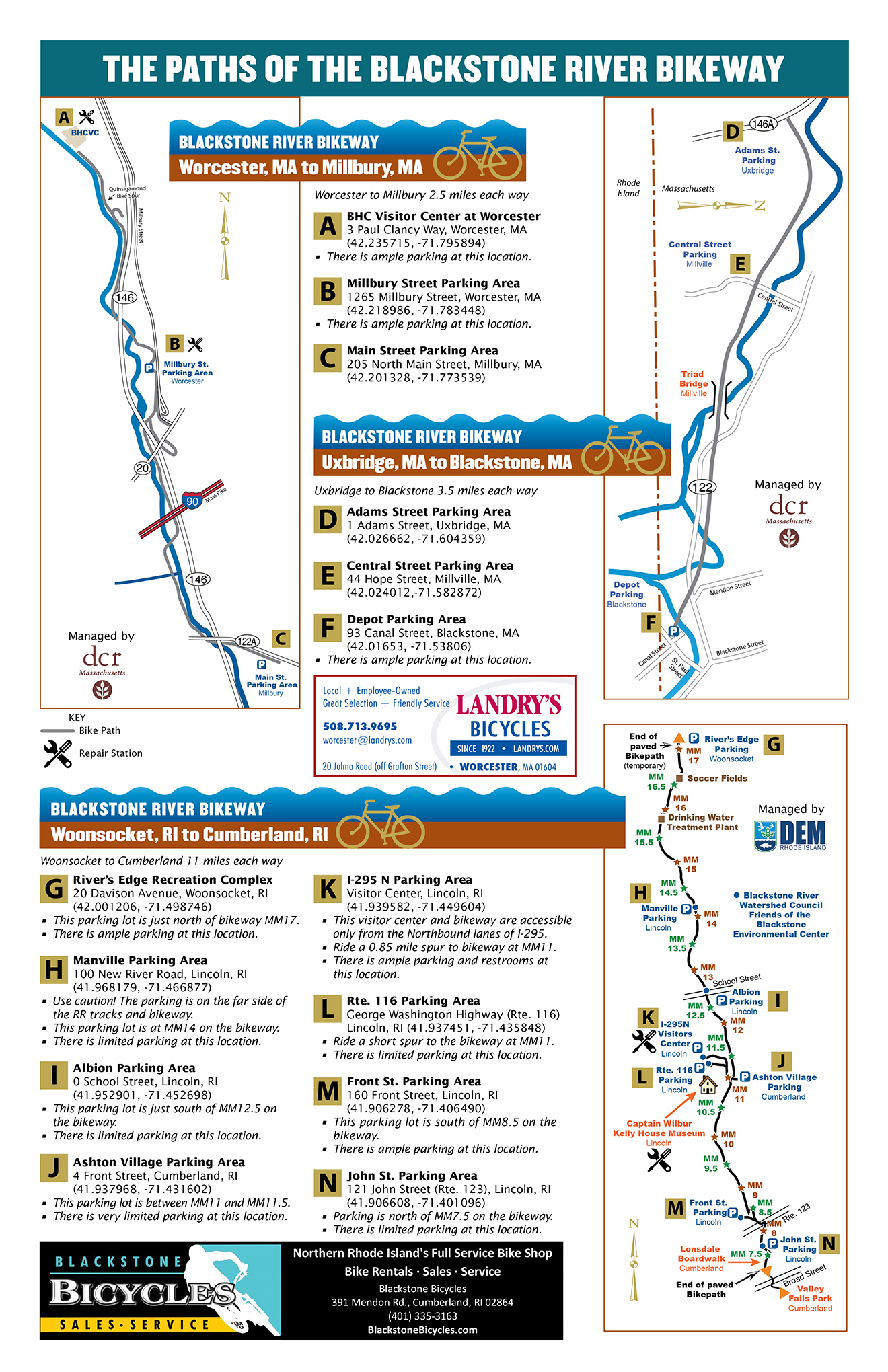
3. Blackstone River Greenway – Worcester to Millbury, MA

The Blackstone River Greenway (also called the Blackstone River Bikeway) is a recreational trail that winds through the spectacular Blackstone Valley. Linking 14 cities and towns in the Blackstone Heritage Corridor, this greenway also connects to the Blackstone River and the Blackstone Canal, forming a riverway where cyclists, walkers, and runners can enjoy the scenic views of the area.
Currently, three completed sections of the bikeway offer more than 17 miles of paved trails. Several on-road segments of the path connect these three main parts of the greenway. As you ride, you’ll pass through Canal Heritage State Park in Uxbridge, filled with historical sites. Further south along the trail, you’ll bike over eight bridges, each offering beautiful views of the Blackstone River and Canal, before reaching the Rhode Island border. Once you get to the segment of the trail that spans Woonsocket, RI to Cumberland, RI, you can follow the path through the Blackstone River State Park and stop at the Captain Wilbur Kelly House & Transportation Museum in Lincoln.
Here is a map of the greenway’s parking areas, all of which you can easily access from various points along the route.
Tips: When completed, the Blackstone River Greenway will also connect to the East Bay Bike Path, so eventually, you’ll be able to continue your ride to Bristol and Newport, Rhode Island.
4. Upper Charles Trail – Milford to Hopkinton, MA

The Upper Charles Trail is a rail trail that’s still developing but will eventually offer 24 miles of gorgeous multi-use trails connecting Milford to Hopkinton, MA. If you start your ride in Milford, the route is V-shaped, giving you the option to head north to Hopkinton or take the northeast branch to Sherborn.
While riding along the north fork of the trail (6.5 miles), you’ll pass Milford Pond and the gorgeous 33-acre Louisa Lake Park. If you like to see lots of wildlife in action while you bike, this section of the route is perfect for you! Along the northeast branch of the Upper Charles Trail (6.7 miles), you’ll bike through the historic Phipps Tunnel, which steam engines once traveled through. You’ll also see the Bogastow Brook Viaduct, a stunning stone bridge with eight arches. Trailside art along this part of the trail also makes it a more unique and fun experience.
There are several parking lots and trailheads for the Upper Charles Trail in Holliston, Milford, and Hopkinton.
Tips: Don’t forget to check out the scenic Dopping Brook Conservation Area, located near the end of the southeast fork of the Upper Charles Trail in Holliston.
5. Ashuwillticook Rail Trail – Lanesborough to Adams, MA

The Ashuwillticook Rail Trail is a paved, 12-mile trail that follows MA 8 through the Hoosic River valley. It links the communities of Lanesborough and Adams in northwest Massachusetts. Bikers love this route for its gorgeous views of the area’s mountains, rivers, and forests. Not to mention the stunning coat of warm-colored foliage it flaunts in the fall!
As you bike the Ashuwillticook Rail Trail, you’ll enjoy the tranquil views and sounds of the forest and the Hoosic River. The trail is nestled between the river and the highway, but a thick layer of trees cushions you from any invasive road noise. As you ride past the Berkshire Pond, you’ll eventually reach the beautiful Cheshire Reservoir, a secluded 418-acre wilderness lake. Definitely stop to enjoy the scenery there, as it offers a breathtaking view of Mount Greylock across the lake, the highest point in Massachusetts! The rest of the trail takes you through farmland and into Adams, where you can check out historic mill buildings on the shore of the Hoosic River and learn more about the area’s rich manufacturing history.
You can park at either trailhead in Lanesborough or Adams to access this trail. You can also park for free at specific public parking areas along the route, detailed here.
Tips: There are places to stop and grab a bite to eat along this route, but unfortunately, they’re all on the opposite side of a busy highway if you start your ride in Lanesborough. Save yourself the trouble and consider packing a lunch or snacks instead.
6. Cape Cod Rail Trail – Yarmouth to Wellfleet, MA

The Cape Cod Rail Trail is a popular destination for cyclists, featuring 27.5 miles of paved and picturesque paths. The route is mostly flat, making it an easy ride for cyclists of all skill levels and a family-friendly option for bikers of all ages.
The Cape Cod Rail Trail route follows old railroad lines that used to shuttle vacationers out to the Cape Cod area. It starts in Yarmouth at Peter Homer Memorial Park and continues through the forest for a couple of miles before reaching a large bridge over the Bass River. You’ll have plenty of opportunities to enjoy picnics, brief detours through nearby communities, stops at quaint general stores, and you’ll even see kettle ponds left behind by melted glaciers. The trail also passes by Nickerson State Park, which offers recreational swimming, camping, hiking trails, and more. Just 1.5 miles from the state park, the town of Orleans is a popular area for tourists and a great place to stop for lunch! It’s also a former Whaling Seaport, home to fascinating history and attractions. From Orleans onward, the trail is very serene, offering beautiful coastal views of the Cape Cod community and its beaches.
Several different trailheads make it easy to jump in and complete a ride on the Cape Cod Rail Trail from any access point.
Tips: A few miles past Orleans, you’ll see signs for the Cape Cod National Seashore Salt Pond Visitor Center, just a half-mile off the trail. Make sure you check it out while you’re in the area!
7. Lynn Woods Reservation – Lynn, MA

The Lynn Woods Reservation is nestled in the small town of Lynn, about 10 miles northeast of Boston. This 2,200-acre forest park offers more than 30 miles of scenic trails for mountain biking and other recreational activities. Many seasoned mountain bikers consider Lynn Woods to be the best mountain biking spot in the state!
The reservation has three lakes. The largest one, Walden Pond, divides it into two sections. South of Walden Pond, you’ll enjoy an exciting maze of singletrack and old fire roads, with mainly easy to intermediate terrain. North of the Walden Pond, you’ll find more challenging trails and extremely rocky terrain, including massive boulders. Lynn Woods Reservation is also known for its five-story stone tower built in the 1930s. Located just over a quarter-mile from the main parking lot, you can climb to the top of this tower and enjoy stunning views of the Atlantic Ocean and the Boston Skyline. While you’re there, don’t forget to check out Dungeon Rock! It’s a cave beneath a gigantic boulder, created by a man in the 1800s. According to legend, he believed pirates buried treasure there, so he spent his whole life searching for it. Unfortunately, he never found the treasure. But now, visitors enjoy the unique cave attraction he left behind.
To get to Lynn Woods Reservation, head to 150 Great Woods Road, Lynn, Massachusetts, 01904.
Tips: Mountain biking is not allowed on the trails at Lynn Woods Reservation in the winter. Plan your trip for summer instead.
8. Border to Boston Trail – Salisbury to Boston, MA

The Border to Boston Trail is an expansive trail that stretches 70 miles from the New Hampshire border to Boston, connecting 20 communities. This route features paved pathways and stone dust trails for relatively easy riding. It’s an incredible way to tour the state, enjoy local wildlife and scenery in the Essex National Heritage Area, and visit historical sites and attractions along the way.
Much of this route is quiet and secluded, although you’ll be riding through primarily suburban areas. While you cycle, you’ll pass over bridges and boardwalks and enjoy serene views of the Merrimack River and other wildlife areas. One of them is the Crane Pond Wildlife Management Area, a protected forest area that spans West Newbury, Newbury, Groveland, and Georgetown. The Border to Boston Trail also passes by the Ipswich River Wildlife Sanctuary, known for its wildlife diversity, particularly the many different species of birds. As you follow the trail to Danvers and Salem, you can visit the historical Rebecca Nurse Homestead and a reproduction of the Salem Village Meetinghouse to learn about the Salem witch trials. Toward the trail’s end in Boston, you’ll cross over the Mystic River and pass through Paul Revere Park, on the banks of the river.
You can park and begin your ride anywhere along the Border to Boston Trail. Here’s a detailed map from the Essex National Heritage Area to help you plan your route.
Tips: Just a heads up: the final leg of the Border to Boston Trail has a packed dirt surface, so it’s better suited to bikes with wide tires.
9. Columbia Greenway Rail Trail – Westfield, MA

The Columbia Greenway Rail Trail is a paved trail through Westfield in southwestern Massachusetts. It’s still a work in progress, but the flat, easy, and family-friendly route is already highly rated and offers a peaceful ride through the community. Featuring bridges, historical sites, and art installations, you’re bound to enjoy this journey.
This trail crosses over several local bridges as it winds through the community, offering easy access to local businesses, parks, and neighborhoods. Sections of the route pass through serene wooded areas and tobacco fields, with educational signs along the trail to help you learn about the history of the area. The trail ends near Shaker Farms Country Club in Westfield, where you can park in a lot off Shaker Road.
Tips: While you’re biking through the downtown Westfield area, Stop by Kismet Brewing Company or Circuit Coffee for a refreshing drink. Or, if you’re biking with little ones, the Amelia Park Children’s Museum is just a short detour from the trail.
10. Vietnam Trails – Milford, MA

The Vietnam Trails in Milford has about 30 miles of mountain biking trails for adventurous bikers to explore. Known locally as just “Vietnam,” these rugged biking routes in central Massachusetts are praised by cyclists for their technical difficulty, although there’s something for bikers of all skill levels at Vietnam.
There are dozens of incredible trails to explore in this versatile area of the Blackstone Valley, but some of the most popular are:
- Tonto – An intermediate doubletrack trail that heads to the southern portion of Vietnam with one steep river crossing along the route
- Adams Lot Trail – An easy singletrack trail that curves all the way up to the Holliston Highway intersection with the Town Forest Trail
- Rubberstamp – A famous Vietnam trail reserved for expert riders only and full of massive jumps, drop-offs, and berms (intimidating banked trails turned on their sides!)
There are several areas to park at Vietnam, but most cyclists park at the Adams Street Parking Lot at 388 Adams Street, Milford. You can easily access all parts of the trail system from this trailhead.
Tips: Vietnam is a fantastic place to explore off-road mountain biking trails in Massachusetts, but it’s more fun with friends! Plan to ride with a group, especially if it’s your first visit to the area.
Interested in another state?
Discover the best US places to ride a bike:
- Alabama
- Arizona
- Arkansas
- California
- Colorado
- Connecticut
- Florida
- Georgia
- Hawaii
- Idaho
- Illinois
- Iowa
- Indiana
- Kansas
- Kentucky
- Louisiana
- Maryland
- Massachusetts
- Michigan
- Minnesota
- Missouri
- Mississippi
- Nebraska
- Nevada
- New Jersey
- New Mexico
- New York
- North Carolina
- Ohio
- Oklahoma
- Oregon
- Pennsylvania
- Rhode Island
- South Carolina
- Tennessee
- Texas
- Utah
- Virginia
- Washington
- West Virginia
- Wisconsin
Tired of hypercompetitive fitness apps?
Enjoy Vingo’s judgment-free community!![]() Explore new worlds on many different terrains
Explore new worlds on many different terrains![]() Personalize your avatar with cool clothes and gears
Personalize your avatar with cool clothes and gears![]() Experience Vingo anywhere on any exercise bike or treadmill
Experience Vingo anywhere on any exercise bike or treadmill


References:
- https://www.alltrails.com/trail/us/massachusetts/bruce-freeman-rail-trail
- https://www.singletracks.com/bike-trails/harold-parker-state-forest/
- https://www.alltrails.com/parks/us/massachusetts/harold-parker-state-forest
- https://blackstoneheritagecorridor.org/exploring-the-blackstone-river-valley/maps-tours-guides/bikepath-access/
- https://www.traillink.com/trail/blackstone-river-greenway/
- https://www.traillink.com/trail/upper-charles-trail/
- https://www.alltrails.com/trail/us/massachusetts/upper-charles-rail-trail–2
- https://www.traillink.com/trail/ashuwillticook-rail-trail/
- https://www.mass.gov/locations/cape-cod-rail-trail
- https://www.traillink.com/trail/cape-cod-rail-trail/
- https://www.nemba.org/trails/massachusetts/lynn-woods
- http://www.lynnma.gov/departments/lynnwoods.shtml#gpm1_2
- https://essexheritage.org/bordertoboston
- https://columbiagreenway.org
- https://www.trailforks.com/region/vietnam-trail-network/
Photo Sources:
John Phelan, CC BY-SA 4.0 https://creativecommons.org/licenses/by-sa/4.0, via Wikimedia Commons
Srs5694, CC BY-SA 3.0 https://creativecommons.org/licenses/by-sa/3.0, via Wikimedia Commons
Magicpiano, CC BY-SA 4.0 https://creativecommons.org/licenses/by-sa/4.0, via Wikimedia Commons
Doug Kerr from Albany, NY, United States, CC BY-SA 2.0 https://creativecommons.org/licenses/by-sa/2.0, via Wikimedia Commons


